TRAVEL DAY 142 - Demopolis to Okatuppa
November 15, 2023
10.67 Hours/ 91.8 Miles
Our boat was on the 6 am lock through list with some 17 other boats in the marina. I fired up the generator, disconnected the shore power, then fired up the engine. In the dark, we eased out of the slip and turned out of the basin into the Tombigbee and south to the Demopolis Lock. The lock was open and ready when we got there and with 2 dead pins (didn't move up or down), all of the vessels had to raft. Just as the doors shut, a call came from another boat that they were a few minutes out. Our crew couldn't believe it, but the lock opened the doors back up and we waited for the straggler.
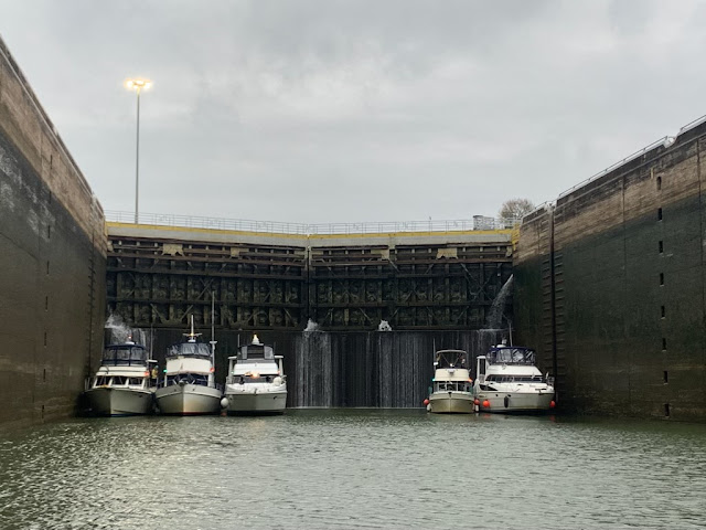 |
| Demopolis Lock |
Once out of the lock we set our sights on a lofty goal of the Okatuppa Anchorage. I pushed Betty up to 2300 rpm and basically kept her there all day. This put our boat at a steady 9 mph. Our fuel burn is 2.5 gph vs our normal 1.9 gph.
 |
| Demopolis Falls |
Ahead of us was Light & Salty, a Gold Looper and Yacht Broker that I had become friends with a year ago but had never traveled with until now. The Camano pushed on and we arrived 20 minutes before dark. We passed 3 other boats in the creek and made 2 attempts to drop the anchor. The second put us in a better position so Runaway could raft to us. Once we were set up, the deck crew dropped our extra anchor to the stern to keep us from swinging.
 |
| Okatuppa Anchorage |
Today was the longest day we have done on the Loop and the crew & captain were exhausted. We made a short night of it, knowing we had another early departure tomorrow.
 |
| Demopolis to Okatuppa |
TRAVEL DAY 143 - Okatuppa to Three Rivers Lake
November 16, 2023
7.57 Hours/ 62.1 Miles
I noticed in the morning, that we had swung some in the anchorage, I tugged on my stern anchor and it was slack. I pulled in the rope to find my Danforth anchor had come off and was now lost on the muddy bottom. Note to self, always use a piece of seizing wire on the Clevis. It was too dark, too early and too cold to go mucking about in the water, so I wrote it off to poor planning. At 5:45 am, I started our engine, pulled the main anchor and moved out of the Okatuppa anchorage and back into the Tombigbee following the other boats ahead.
 |
| Coffeeville Lock |
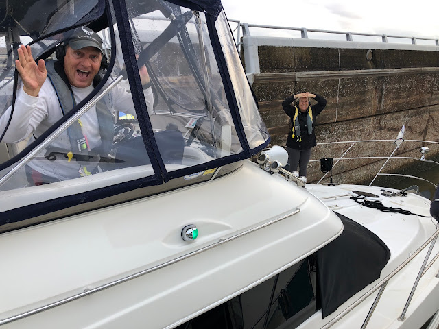
Passing Bobby's Fish Camp on the starboard side, we rounded the corner to our final lock of the Tombigbee. It also marks the last lock we will do on this trip. Entering near last in the chamber, we rafted to Runaway and called the lockmaster to say we were secure. Each vessel was required to call the Lockmaster prior to entering and provide their registration number. One boat failed to do that and was chastised by the Lockmaster "Captain, you don't enter my lock until I give you permission". Once secure, we cranked up the music and danced to "The Bird" by Time. Every skipper in the lock was dancing.
 |
| Goodbye locks! |
 |
| Runaway does "The Bird" |
We are now back in tidal waters and the outward flow gave us an extra push seaward and downriver. Coming out of the Coffeeville Lock the scenery was not great, the shoreline looked "scraggily". Today was another run under overcast skies and cool temperatures so we stayed at the lower helm with the heat on. The Tombigbee takes some incredible horseshoe bends that nearly meet each other, two and three in a row. A ditch cut between these sure would cut the miles down.
 |
| River Debris |
Another thing we noticed was that unlike many of the other waterways, the ATONs (Aids TO Navigation/red & green markers) were not well maintained and many were missing or off station. I'm sure with heavy tow traffic, tight turns and a narrow waterway, the markers get wacked pretty frequently. At mm 40 the Mobile River joins the Tombigbee. The current has picked up some and we easily motor down the brown river. The amount of logs and debris has increased substantially and we have to be ever vigilant to avoid a log strike.
 |
| Bow to Stern Anchor |
We made our anchorage and proceeded to move to the back. There was another boat there already anchored. We attempted to drop the anchor twice but it skidded along the bottom. I assumed the bottom content must be hard clay as Runaway made two unsuccessful attempts as well. Pivoting, we traveled back to the mouth of the creek and dropped the hook, it immediately sunk into the bottom. Again we rafted to Runaway, this time bow to stern since I no longer had a spare stern anchor
 |
| Invaded by Asian Lady Beetles |
As soon as we got set up we were inundated with what we thought was a swarm of ladybugs. They actually turned out to be Asian Lady Beetles, an invasive species introduced in the 60's by the Department of Agriculture to control agricultural pests, it didn't work, big surprise.
 |
| Okatuppa to Three Rivers Lake |
TRAVEL DAY 144 - Three Rivers Lake to Big Bayou Canot
November 17, 2023
6.32 Hours/ 55.9 Miles
I still never trust my fuel gauge and I added my reserve 10 gallons of diesel just to be sure. We inch ever closer to the end of the Tombigbee River and the entrance to Mobile Bay. Anchoring out on this waterway has been excellent. Each night we have been treated to a secluded area and a quiet night's sleep. A leisurely start this morning as we moved back into the waterway, calling the tows as they appear on AIS and passing on their dictated side.
 |
| Three Rivers Lake Sunrise |
The Tombigbee ended at the intersection of the Alabama River and we are now on the Mobile River. As we approached a bend in the river, we noticed 3 Looper vessels stationary in the river. I called and was told that Gypsy had picked up a Hawser Line in their prop. A Hawser Line is an extremely large rope used by the tows to pull and lash the barges together. It is not uncommon to have one of these lines caught in a prop and will assuredly stop the engine and paralyze the vessel. I offered to jump in the water with a wetsuit, mask & fins to see if I could get it untangled. The water was 66 degrees and a little on the chilly side. The visibility was about a foot if that. With each breath I pulled a little of the line off but it was way to snarled and there was no way I could hold my breath long enough to make any headway. I lamented that I had left my dive gear back at home. TowBoat US had been called so we had to leave Gypsy waiting at anchor for their tow to Dog River.
 |
| A failed rope removal |
At least today was rather warm and the sun was shinning. The vessel ahead of us called the CSX Railroad Bridge for an opening and we all made it under and to our anchorage at Big Bayou Canot. We turned into the creek to see the railroad bridge that was the sight of one of the worst railway disasters in American history. On September 22, 1993 the bridge was struck in thick fog by a tow of heavy barges and kinked the track. About 8 minutes later, an Amtrak passenger train, the Sunset Limited from LA to Miami derailed, killing 47 people and injuring 103 more.
 |
| A quiet anchorage |
 |
| Sunset towards Mobile Bay |
Now this site is a quiet anchorage except for the occasional trains that still use the track and bridge. Still traveling with Runaway, we had to be mindful of a current change so we set up in the middle of the creek to allow for the current reversal and boat swing. Anticipating a beautiful sunset, I set out the drone and we had docktales on the bow.
 |
| Three Rivers Lake to Big Bayou Canot |
TRAVEL DAY 145 - Big Bayou Canot to Mobile Bay
November 18, 2023
2.75 Hours/ 24.3 Miles
This is it, today we say goodbye to the Inland River System as we exit the Mobile River and into Mobile Bay! The Mobile River at this point is extremely busy. Multiple tows met us as we traversed the wide fairway. Passing under the Bay Bridge the shoreline became very industrial, monster ships, shipyards and loading docks. Coal yards and fuel storage facilities with huge cranes lined the seawalls. We were glad it was a Saturday, a weekday would have been crazy busy.
 |
| Constant upriver tows |
It was a short run past the downtown as the waterway opened up to Mobile Bay. The bay was a little choppy with a steady north wind at our backs. We knew the Gulf of Mexico was straight ahead 25 miles in the distance. Our first dolphin appeared as he rolled near the forward port side of the boat. No more freshwater pulsing through the engine components.
 |
| Bay Bridge |
I followed the channel markers nearly straight south for 7.5 miles before turning to starboard to follow the Dog River Channel in and under the Dauphin Island Bridge and into Dog River. Down to idle, we approached the Grand Mariner Marina and after several calls on the radio we were ushered in to our slip.
 |
| Hospital Ship Comfort |
A decent marina, a little rough but power, restrooms, a shower and a restaurant, fuel & pump out on site. The crew rested some as I chatted with the Captain of Runaway about the incoming high winds and what it meant for our travels across Mobile Bay and down to the coast. We decided to alter our plans some & rearrange a reservation or two.
 |
| Pulling in the slip |
The River Rats met for an overpriced dinner. The food was good, but way too much. Unfortunately, we were low on provisions since Demopolis and this was basically our only option.
 |
| Big Bayou Canot to Mobile Bay |


Comments
Post a Comment